How to Set Up a Collaborative GeoJSON Review for AI Mapping Agents
Validating GeoJSON data is one of the most expensive parts of building autonomous systems. When mapping agents and human reviewers work in separate silos, costs spiral and metadata errors slip through. This guide shows you how to set up a shared workspace where agents and humans collaborate in real-time. By using automated validation and intelligent indexing, teams can speed up the review cycle while keeping coordinates accurate.
Why Spatial Data Processing Costs So Much
Building autonomous systems requires a massive amount of high-fidelity geographic data. But for most teams, the cost of validating this data is a major hurdle. According to Capgemini, spatial data processing and annotation can take up multiple% of the total budget for autonomous mapping projects. This cost usually comes from the manual work needed to check AI-generated features against satellite imagery or ground truth data.
GeoJSON is the standard for these workflows, used in about 90% of web-based GIS applications. It is easy to read, which makes it good for collaboration, but standard cloud storage often lacks the tools mapping teams need to handle metadata-heavy reviews. Without a workspace where agents can upload results and humans can check them immediately, the final stage of data production becomes a slow and expensive manual process.
Helpful references: Fastio Workspaces, Fastio Collaboration, and Fastio AI.
How Mapping Agents Work in Practice
Mapping agents are autonomous programs that take raw sensor data, like LiDAR or satellite imagery, and turn it into structured formats like GeoJSON. These agents work at a scale humans cannot match, identifying road markings and building footprints across thousands of kilometers in minutes. They are the engine behind modern map production, often finding details that human eyes might miss in grainy imagery.
In a professional GIS setup, these agents should be active participants in a digital data room. For example, an agent can use URL Import to pull raw imagery directly from AWS S3 or Google Drive. This lets the agent handle massive datasets without slowing down local networks. Once a file is ready, the agent can use File Locking to prevent anyone from making edits while it finalizes the data. This stops the "conflicting edit" issues that often slow down large GIS teams.
Agents can also react to changes using Webhooks. When someone uploads a new image to a folder, a webhook triggers the agent to start processing it right away. This cuts down the wait time for map updates and keeps the database current. Moving from static files to a reactive pipeline helps the whole system scale as more data comes in.


Collaborate on Files with Your Team
Get generous storage and 19 consolidated tools during the trial for your AI mapping agents. No credit card required. Built for collaborative geojson review mapping agents workflows.
Step-by-Step GeoJSON Review Workflow
High-quality map data depends on connecting automated output with human oversight. A structured workflow ensures every geographic feature is checked before it goes into production.
Set Up a Shared Workspace: Create a space where both human reviewers and AI agents have the same access. Agents can join through the API or MCP, using the same search and chat tools as the rest of the team. 2.
Automate Data Ingestion: Set your agents to use URL Import for raw data. This pulls files directly from sources like Google Drive, so the agent always works with the latest version. 3.
Run Automatic Checks: Use MCP tools to run checks on GeoJSON files as soon as they are uploaded. An agent can flag missing metadata or coordinate errors before a human even opens the file. 4.
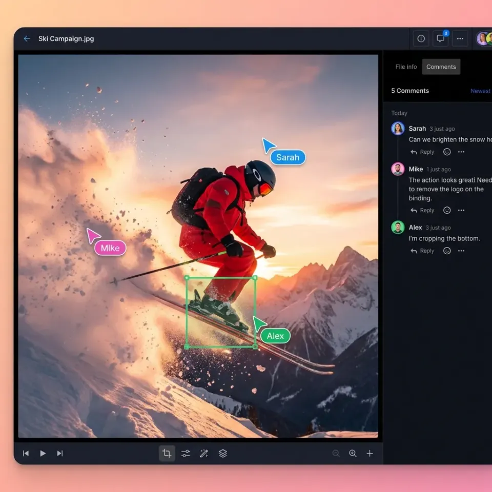
Human Review: Humans use the workspace to inspect the agent's work. Since everything is indexed, you can use Intelligence Mode to ask things like, "Which features have a confidence score below multiple.8?" and get a list of links to those files. 5.
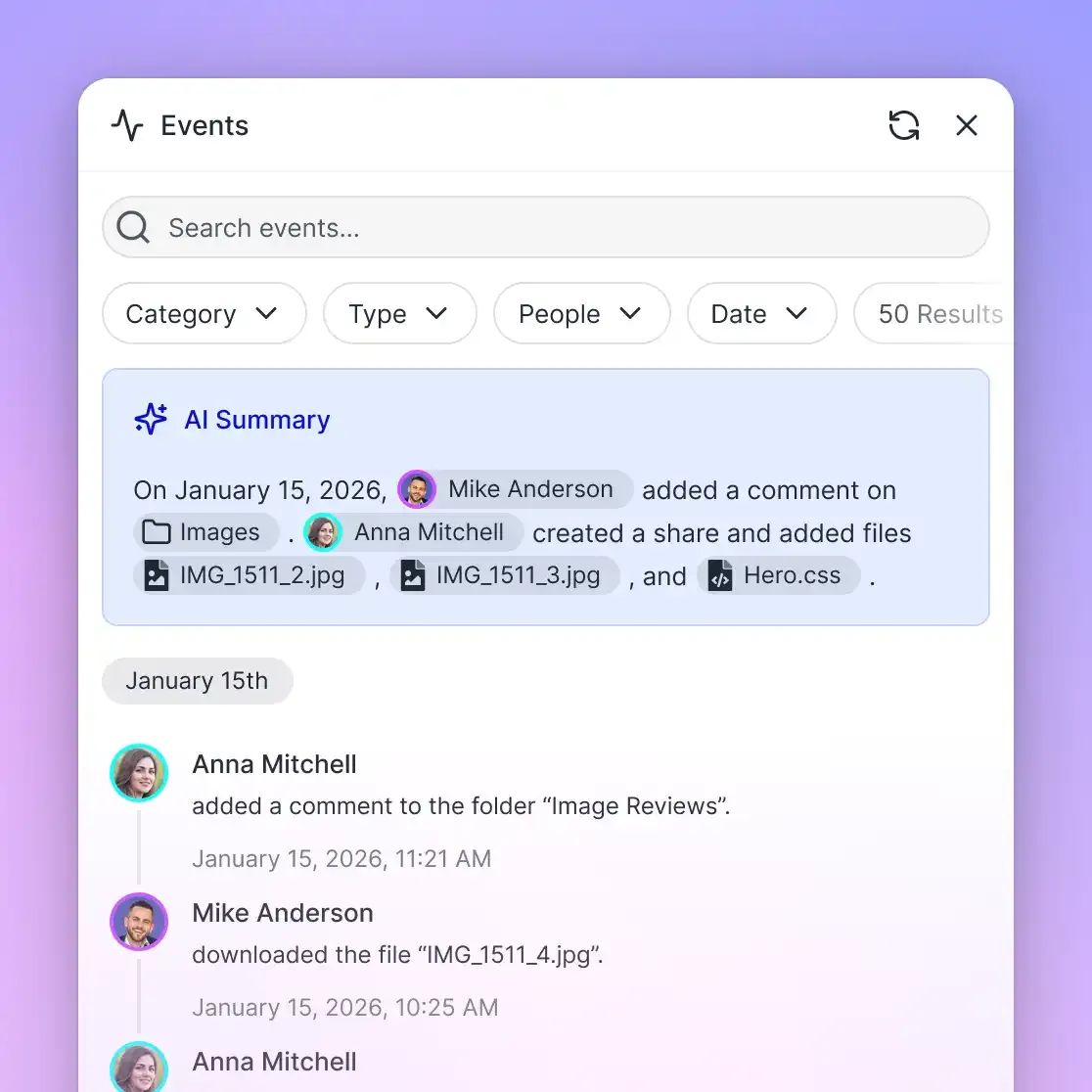
Transfer Ownership: Once the data is ready, the agent uses Ownership Transfer to hand the assets to the project lead. This creates a clear audit trail showing exactly how the data was approved.
Why Shared Workspaces Matter for GIS
Most platforms treat GeoJSON like any other text file. We treat it as data that needs to be understood. Fastio provides the coordination layer that standard storage is missing.
19 consolidated tools for Automation Your agents get access to over multiple tools for managing files and workspaces. This lets them be proactive. If an agent finds a mistake, it can lock the file, run a fix, and then release it once the coordinates are right.
Built-in Search and Citations When you turn on Intelligence Mode, all GeoJSON files are indexed automatically. This means you do not need to build a separate database to search your mapping data. You can find what you need using natural language, with answers that link directly back to your files.
Free Tier for Developers We offer a free tier for agent developers that includes multiple of storage and multiple monthly credits. This makes it easy to test your GeoJSON workflows without worrying about upfront costs or trial periods.
Solving Common Validation Challenges
Handling GeoJSON at scale brings up technical issues that a simple coordinate check cannot catch. For mapping agents, the hardest problems are often about projections, precision, and nested metadata.
Handling Projections Most GeoJSON uses WGS multiple, but many older GIS datasets use local projections. When an agent pulls data from different sources, it has to transform those coordinates so they line up. A shared workspace lets agents flag projection errors immediately, saving human reviewers from looking at misaligned maps.
Keeping Coordinates Precise High-precision mapping needs sub-meter accuracy, which means keeping six or seven decimal places in your GeoJSON. Some libraries cut these numbers off to save space, causing the map to "drift." Using storage with strict rules ensures agents do not lose this precision during the upload.
Checking Complex Metadata The value of a GeoJSON file is often in its properties, like confidence scores or classification labels. Checking thousands of these by hand is impossible. In a smart workspace, agents can run scripts to check every property against a schema. If a field is missing, the agent can re-process the feature before it ever reaches a human reviewer.
Real-World Impact: Faster Cycles and Better Data
Moving from scattered storage to a unified workspace changes how fast projects move. Teams using these workspaces see clear improvements in both speed and quality. For instance, one mapping project used agents to process multiple square kilometers of imagery in less than a week. By using a shared workspace for review, the team cut the human validation phase by multiple%.
- Faster Approvals: When agents and humans use the same tools, the time between data generation and approval drops. Reviewers can leave comments directly on the data instead of sending emails.
- Simpler Infrastructure: You do not need extra middleware to connect agents to storage. The workspace acts as the single source of truth for both the agent output and the human feedback.
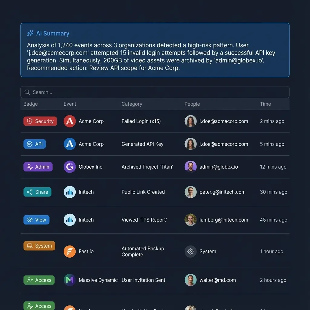
- Better Audit Trails: Every change is tracked. This is essential for safety-critical work like autonomous driving, where you need to know exactly who changed a geographic feature and why.
As autonomous systems expand, GeoJSON collaboration will become a requirement for every GIS team. Platforms that focus on how humans and agents work together are no longer just a nice feature. They are necessary for building and scaling modern mapping infrastructure.
Frequently Asked Questions
How do I collaborate on GeoJSON files?
The best way to collaborate on GeoJSON is to use a shared workspace where both humans and AI agents have access. This lets agents upload data while humans use search and intelligence tools to check coordinates and metadata in real-time.
What are AI mapping agents?
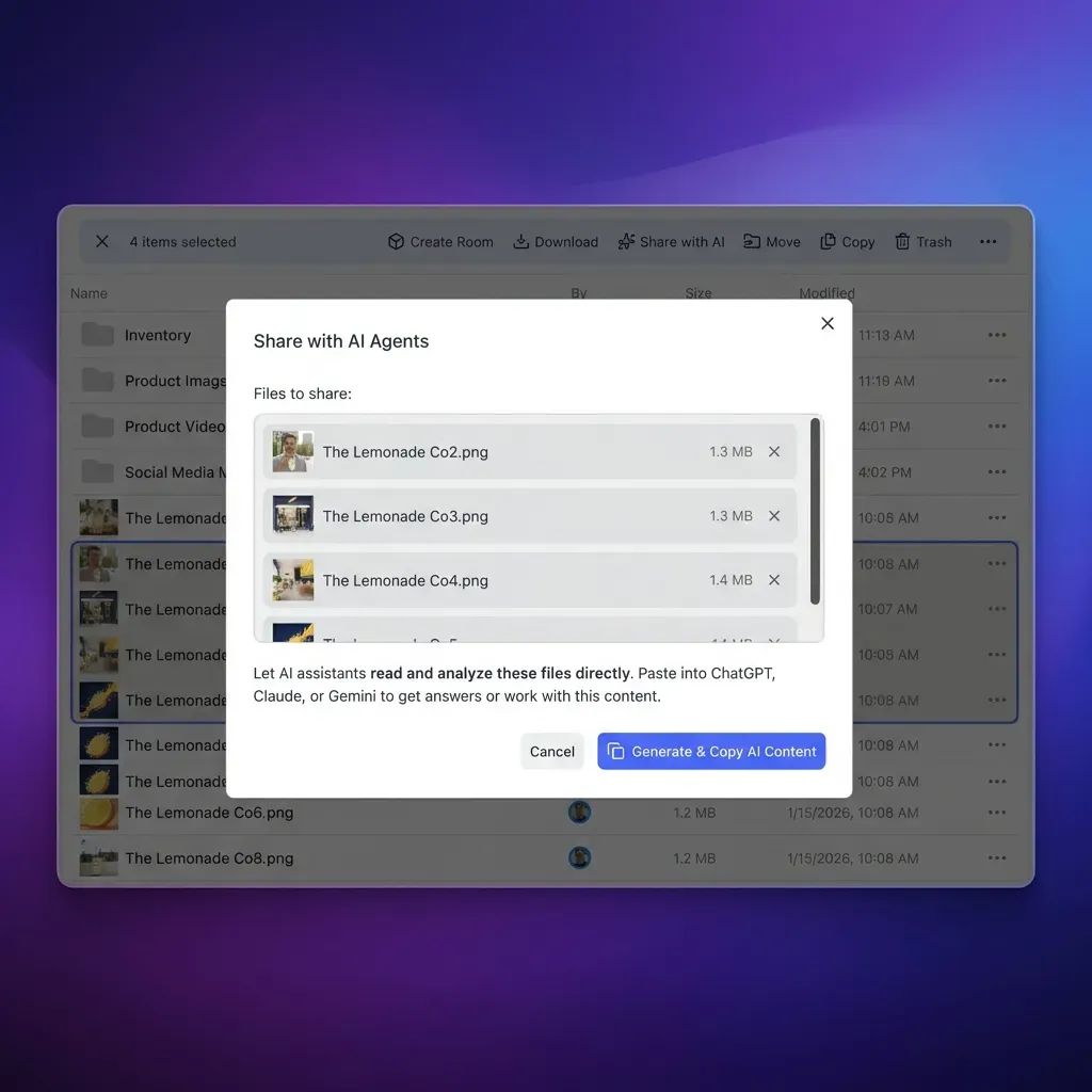
AI mapping agents are programs that turn raw sensor or imagery data into structured geospatial files. They use tools like MCP or OpenClaw to interact with storage, run validations, and hand off finished work to human teams.
Why is GeoJSON used for web-based GIS?
GeoJSON is used in about multiple% of web GIS because it is easy for humans to read and works natively with JavaScript. This makes it simple to use in web browsers and allows for complex data to be stored alongside coordinates.
Can I use Fastio with any LLM?
Yes. Fastio works with any model, including Claude, GPT-multiple, Gemini, and local LLMs. You can connect agents using our MCP server or install the OpenClaw skill.
Does Fastio support large mapping datasets?
Yes. The platform is built for high-performance data. The free tier supports files up to multiple, and paid plans can handle much larger datasets like city-scale mapping and LiDAR point clouds.
Related Resources

Collaborate on Files with Your Team
Get generous storage and 19 consolidated tools during the trial for your AI mapping agents. No credit card required. Built for collaborative geojson review mapping agents workflows.